The joy of taking my characters to places I’ve never been, at a time that’s poorly documented? Or, how did I recreate Winchester and Canterbury for Enemies of Mercia?

These days, it can be ‘quite’ easy to recreate places you’ve never visited. Virtual reality can help, as can simply using mapping software or a good old map. But what do you do when the period is so distant, the current infrastructure has almost obliterated what little remains of the period, and you’ve never visited the location?
This happens to me a great deal when writing about Saxon England. I’ve long been very reliant on An Atlas of Anglo-Saxon England by David Hill (published in 1981), which I was lucky enough to get my hands on a second-hand copy of some years ago. While it’s very good for making sure the places I take my characters might have existed at that time, the specifics can be more difficult.
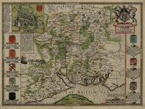
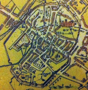
Luckily, I have an ace up my sleeve. My father is known as Mapman Michael, and he has maps of many, many places (not just in the UK), and on many an occasion, I’ve simply asked him if he has a map of, say, Winchester from 1610. These maps, created by the cartographer John Speed and depicting every English county (not the ‘new’ ones from the 1970s but the ‘old’ ones including names you might not have heard of, such as Westmoreland), benefit from not only showing the counties in the early seventeenth century, but also, if you’re lucky, have a smaller map included of the county town, and often, one other location as well. I’ve found them for Winchester, Lichfield, Northampton, Canterbury and many other places. (And I’m not alone in using them – archaeologists also use them). Consulting these maps allows a much less congested world to be recreated – before many of the huge road networks and railway lines and canals were built.
Having a map, however, is not always the answer. I often confuse my north, south, east and west, and sometimes, trying to determine which road or river went where can be complicated – as can knowing whether rivers were navigable at the time or not. Winchester and Canterbury, are luckily, well studied. All the same, it took me grabbing hold of the English Heritage guidebook for St Augustine’s Abbey, Canterbury, to be convinced that it was not inside the ancient walls, despite having the ancient maps to consult. Names have changed, and when you don’t know where you are, the desire not to make a silly mistake can lead you down all sorts of rabbit holes.